Overview
Brenda gold-copper Porphyry Project, British Columbia, Canada
Summary:
- 4,450 hectares (10,990 acres), 100% owned, no underlying royalties
- Excellent road access and infrastructure
- 20 km NW of South Kemess past producing mine
- Moderate topography, porphyry zone at 1,500m elevation
- Over $4.0 million in exploration expenditures to date
- Over 12,000 metres diamond drilling in 65 drill holes
- Geochemical surveys
- Satellite, airborne & ground geophysical surveys
- Confirmed gold-copper porphyry mineralized zone 500m x 200m
- Large argillic alteration zone mapped over 1.5 km by 750 metres
- Significant gold-copper intersections encountered in earlier drilling up to 0.697 g/t gold and 0.088 % copper over 169 metres and 0.707 g/t gold and 0.119% copper over 59 metres
- 2007 drill program confirmed gold-copper mineralization down to a depth of 550 metres and open to depth, with intercept grades up to 0.867 g/t gold and 0.141% copper over 38 metres
- 2007 3-Dimensional Induced Polarization Geophysics indicates porphyry gold-copper target open to the northeast and southwest. Further aerial geophysics and deeper sensing IP surveys recommended to define drill targets for future testing
Feb. 10, 2021: Updated NI 43-101 Technical Report on the Brenda Gold-Copper Project
For highlights of the updated Technical Report refer to the news release dated Feb. 10, 2021, under the News Releases section.
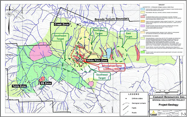
The report concludes that the Brenda project is a Cu-Au±Mo porphyry system with potentially elevated gold and copper grades due to reactive intermediate to mafic host rocks cut by high-K calc-alkalic intrusions similar to those at important porphyry deposits worldwide. Multiple targets for additional copper-gold mineralization exist northeast, southeast, southwest and east of the previously drilled Mineralized Zone (MZ). Maps outlining the MZ and prospective target areas are included below for reference.
The updated Technical Report is based on the results of a comprehensive review of the project data including three dimensional geological modelling of the central White Pass zone, and identification of prospective targets based on surface and downhole geochemical analysis using the porphyry elemental zoning model of Halley et al. (2015)1. Further evaluation included re-logging of available skeleton core and refined targeting based on analysis of drilling and soil geochemical data, applying the MDRU Porphyry Index or MPIx (Bouzari et al., 2019)2, to vector towards higher grade Cu-Au mineralization.
These studies confirmed the project’s potential for hosting a large gold-copper mineralized system and recommended further exploration to test the multiple targets identified, as well as to expand the mineralized zones already delineated by past exploration and drilling. The recommended exploration program includes 7,000 metres of diamond drilling, with a Phase 1 budget of $877,000 and Phase 2 budget of $1,251,000, for a total budget of $2, 128,000.
1 Halley, S., Dilles, J.H., and Tosdal, R.M., 2015, Footprints: Hydrothermal alteration and geochemical dispersion around porphyry copper deposits: SEG Newsletter, no. 100, p. 1, 12-17.
2 Bouzari, F., Bissig, T., Hart, C.J.R., and Leal-Meija, H., 2019, An exploration framework for porphyry to epithermal transitions in the Toodoggone mineral district (94E): Geoscience BC Report 2019-18, 105 p.
The report titled “NI 43-101 Technical Report on the Brenda Gold-Copper Project” dated February 03, 2021, was prepared by Robert A. (Bob) Lane, M.Sc., P. Geo., of Plateau Minerals Corp. Mr. Lane is a Qualified Person as defined under National Instrument 43-101 of the Canadian Securities Administrators - Standards of Disclosure for Mineral Projects.
Canasil Brenda Gold-Copper Project, Kemess-Toodoggone District, BC, Canada – Feb. 10, 2021
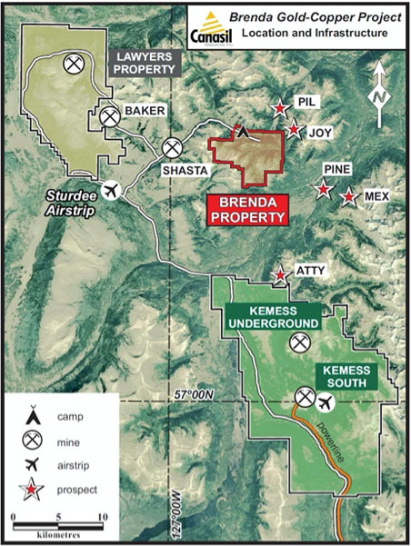
Neighbouring Mines and Prospects, Access and Infrastructure
Canasil Brenda Gold-Copper Project, Kemess-Toodoggone District, BC, Canada Feb. 10, 2021
Clay Alteration Zone (Yellow), >0.1 g/t Gold Mineralized Zone (Red), Multiple Exploration Targets (Green)
Canasil Brenda Gold-Copper Project, Kemess-Toodoggone District, BC, Canada – Feb.10, 2021
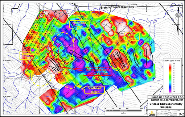
Copper Soil Geochemistry - Multiple Exploration Targets (Yellow)
February 3, 2021
NI 43-101 Technical Report on the Brenda Gold-Copper Project
September 12, 2017
NI 43-101 Technical Report on the Brenda Gold-Copper Project
Introduction:
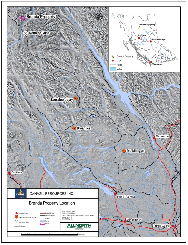
Canasil’s Brenda property is an advanced exploration project centrally located in the Kemess-Toodoggone porphyry gold-copper/epithermal gold district. The property comprises 178 mineral claim units covering 44.0 square kilometres and is situated approximately 20 km northwest of the past producing Kemess South mine. It is located 15 km northwest of Centerra Gold’s (ex AuRico Metals) Kemess Underground and Kemess East deposits, which are undergoing pre-production reviews. Between 1998 and 2011, Kemess South produced approximately 3.0 million ounces of gold and 750 million pounds of copper from 218 Mt of ore.
The property is 100% owned by Canasil and all claims are valid to May 30, 2024. Cumulative exploration expenditures to date amount to over C$4,000,000, including geochemical surveys, satellite, airborne and ground geophysical surveys, and over 12,000 metres of diamond drilling in 65 drill holes.
Exploration work on the Brenda property to date has confirmed the potential for a large gold-copper porphyry system, which is open for extension and warrants further exploration. Diamond drilling to date has returned significant gold-copper porphyry mineralized intersections, e.g. DDH-97-3 with 39.95 metres of 1.12 g/t gold and 0.18% copper, BR-03-07 with over 160 metres with 0.565 g/t gold and 0.079% copper, and BR-07-04 with 58 metres of 0.70 g/t gold and 0.12% copper. These grades compare favourably with the average proven gold and copper grades observed in known porphyry deposits in the Kemess-Toodoggone district. The property has seen little drilling since 2007.
Past drilling outlines a tabular mineralized body striking southwest-northeast over an area of approximately 1,000 metres by 400 metres to approximate depths of 100 metres to 550 metres with average grades of 0.41 g/t Au, 0.066% Cu and 2.74 g/t Ag.. Within this envelope there is a higher grade zone of approximately 200 metres by 300 metres and depth of 150 metres with an average grade of 0.659 g/t Au, 0.092% Cu and 3.32 g/t Ag. Gold and copper grades appear to be increasing with depth. Geochemical, geological and geophysical signatures indicate a potential target zone covering an area of approximately 2,000 metres by 750 metres extending to the northeast and southwest of the area drilled to date. This area has not been tested by drilling and further exploration and drilling is required to potentially extend the gold-copper porphyry system.
Location, Access and Infrastructure
The Brenda Property is located in the Kemess-Toodoggone porphyry gold-copper / epithermal gold district in north central British Columbia, approximately 450 km north of Prince George and 20 km northwest of the past producing Kemess South Mine. It is also situated 15 km northwest of Centerra Gold’s (ex AuRico Metals) Kemess Underground and Kemess East deposits. The property has excellent road access from Prince George by way of the Omineca Resource Access Road and logging roads, with direct road access onto the property. The Kemess mine airfield is located approximately one hour drive from the property, and the Sturdee Valley airstrip is located 21 km west of the property. The significant infrastructure developed for the Kemess mine (air and road access, electricity etc.) presents a major advantage for the cost-effective development of the property. The terrain in the project area is moderate offering ease of access within the project area, with the porphyry target zone at a moderate elevation of 1,600 metre.
Project Geology
The property is in the Toodoggone-Kemess porphyry copper-gold and epithermal gold district, situated within a Mesozoic volcanic arc assemblage along the eastern margin of the Intermontane Belt, a northwesterly trending belt of Paleozoic to Tertiary sedimentary, volcanic and intrusive rocks. The region is dominated by northwest and northeast trending block faults.
The Brenda property is underlain by Upper Triassic Takla Group volcanic rocks, uncomformably overlain by Lower to Middle Jurassic Toodoggone volcanic stratigraphy of the Hazelton Group, and intruded by monzonite and felsic plutons, dykes and sills, thought to be co-magmatic with the Toodoggone rocks. The Brenda property is located near the transition from predominantly porphyry gold-copper mineralization to the south, to epithermal type gold-silver mineralization in the northwest. The numerous precious metal-bearing epithermal type vein deposits and deeper seated porphyry gold-copper deposits are thought to be associated with the Jurassic magmatic event.
Early Exploration
The project was initially recognized due to the occurrence of placer gold in Jock Creek and epithermal gold-bearing quartz veins in the west and northwest of the property. Samples from these veins returned values of up to 42.16 grams/tonne gold and 1,628.3 grams/tonne silver.
Subsequent geochemical and geophysical surveys indicated the potential for porphyry type mineralization on the property. This work outlined a 900 metre by 400 metre gold and silver geochemical anomaly, named the White Pass zone, located in the centre of the property, and two other coincident geochemical and geophysical targets, which include the East Creek and Creek zones. Between 1992 and 1997, approximately 2,900m of diamond drilling was completed in 24 holes with an average depth of 120m, restricted to an area of 350m x 100m within this anomalous zone. Significant intersections from this drilling are listed below:
|
Hole
|
Interval (m)
|
Length (m)
|
Cu (%)
|
Au (gpt)
|
|
DDH 93-1
|
9.14 – 57.00
|
47.86
|
0.130
|
1.10
|
|
DDH 93-3
|
12.20 – 121.00
|
108.80
|
0.144
|
0.48
|
|
DDH 96-3
|
15.54 – 41.75
|
26.21
|
0.100
|
0.92
|
|
DDH 96-7
|
7.30 – 69.80
|
62.50
|
0.140
|
0.84
|
|
DDH 97-1
|
148.0 – 172.8
|
24.80
|
0.130
|
1.12
|
|
DDH 97-2
|
35.35 – 75.30
|
39.95
|
0.180
|
1.12
|
Exploration – Northgate Option 2002 to 2004:
Northgate Minerals Corp. undertook exploration programs in the 2002, 2003 and 2004 field seasons under an Option agreement dated in July 2002. This work included airborne magnetic and radiometric geophysical surveys, as well as satellite imaging surveys, followed by 4,581m of diamond drilling in 14 drill holes in the White Pass zone from 2002 to 2004. In November 2004 Northgate terminated the option agreement with no interest earned.
Based on the results from these programs, Northgate established that a Kemess-style gold-bearing copper porphyry system is present at Brenda. Copper and gold mineralization was intersected in all drill holes, confirming the presence of a large gold-copper porphyry system. Diamond drilling by Northgate tested the mineralized system to a depth of approximately 450 metres and returned significantly longer intersections of gold and copper mineralization (up to 243 metres) than those encountered in previous drilling as shown in the table below, together with a table showing average grades from the Kemess South and Kemess North deposits for reference.
Brenda Project 2002 – 2004 Significant Drill Intercepts
|
Hole
|
From
|
To
|
Length (m)
|
Cu %
|
Au g/t
|
|
Drill intercepts 2002 – 2004
|
|||||
|
BR-04-10
|
91.4
|
251
|
159.6
|
0.038
|
0.411
|
|
and
|
263
|
346
|
83
|
0.021
|
0.496
|
|
incl.
|
331
|
346
|
15
|
0.032
|
0.888
|
|
BR-04-12
|
65.5
|
103.6
|
38.1
|
0.091
|
0.362
|
|
and
|
108.2
|
128
|
19.8
|
0.08
|
0.539
|
|
and
|
131.1
|
144.8
|
13.7
|
0.097
|
0.346
|
|
and
|
153.9
|
169.2
|
15.3
|
0.072
|
0.285
|
|
BR-04-14
|
142
|
156
|
14
|
0.017
|
0.601
|
|
and
|
343.1
|
448
|
104.9
|
0.031
|
0.399
|
|
Incl.
|
418.4
|
442
|
23.6
|
0.029
|
0.755
|
|
BR-03-06
|
58.9
|
120.8
|
61.9
|
0.128
|
0.440
|
|
BR-03-07
|
100.5
|
262.1
|
161.6
|
0.079
|
0.565
|
Geological Mapping Program – 2006:
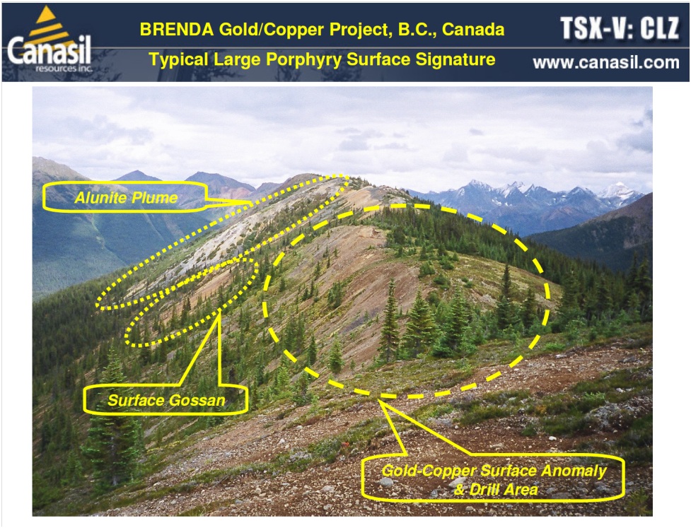
A geological mapping program, carried out by Dr. Andre Panteleyev, outlined a large advanced argillic alteration zone, which is viewed by him as representing the upper levels of a copper gold porphyry system, and which has not been tested by earlier drilling.
This alteration zone is capped with quartz alunite and lies immediately to the northeast of the previously drilled White Pass copper-gold porphyry area. The zone trends north-south and measures approximately 1200 metres north-south by 800 metres east-west, and is open to the south. Earlier drill holes located immediately adjacent to the alteration zone to the southwest (93-03, 03-06, 03-07, 04-10 and 04-14) are highly anomalous in copper and gold, display strong argillic alteration (illite) overprinting albite and propylitic alteration, some with gypsum and fluorite veining. Grade and intercept lengths appear to be increasing to the northeast towards the large newly mapped alteration zone. The alteration is characterized by strong clay (illite) alteration with iron oxides after pyrite, pyrite, minorsecondary copper minerals and sphalerite. Quartz alunite ribs, or ‘ledges’, are present at higher elevations. The zone is associated with anomalous gold and molybdenite soil geochemistry and is rimmed by anomalous zinc and lead soil geochemistry. The features of this large alteration zone are characteristic of the upper levels of copper gold porphyry systems.
Diamond Drilling and Geophysics – 2007 and 2013:
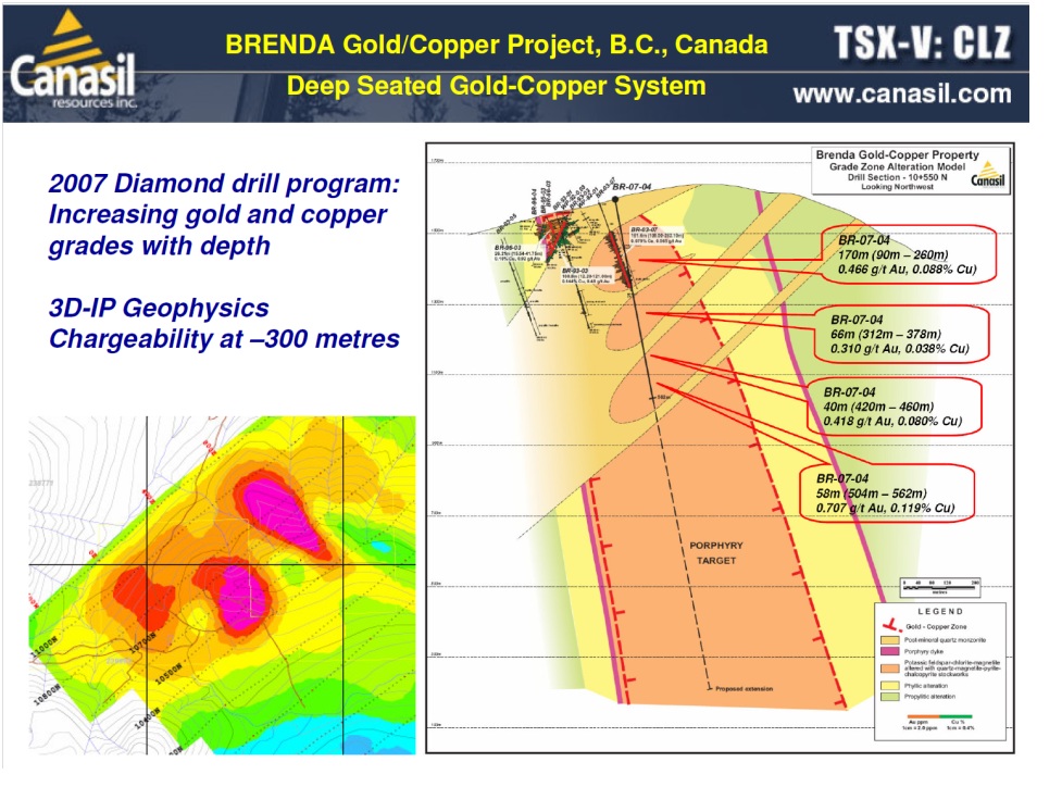
A 1,708 meter diamond drill program in 5 diamond drill holes, as well as a 3-dimensional Induced Polarization geophysical survey, was completed during the 2007 field season. These programs identified potential for a deep porphyry gold-copper system at the Brenda project. Drill holes BR-07-04 and BR-07-05, drilled to a depth of 562 metres and 530 metres respectively, both intersected broad gold-copper mineralized zones with increasing grades at depth, and which were also open to depth.
The average grade of 5 intercepts from both holes above a depth of 450 metres (Nos. 1, 2, 3, 5 and 6 in the table below) was 0.48 g/t gold and 0.079% copper over a combined intercept width of 393.72 metres. The average grade of 3 intercepts below 450 metres (Nos. 4, 7 and 8 below) was 0.68 g/t gold and 0.116% copper over a combined intercept width of 92.84 metres. A significant number of samples returned assays of over 1.0 g/t gold and 0.15% copper. A follow up drill hole aimed to twin drill hole BR-07-04 was completed in 2013 to a depth of 962 metres. This drill hole did not intersect significant mineralization below the level of the deepest intercepts of BR-07-04 at 550 metres. Additional geophysics and drilling is recommended by the Company’s consultants who believe the system will continue to depth.
The increasing gold and copper grades at depth and the strength of the highly altered mineralized structure observed in the drill core, in conjunction with the strong anomalies observed in the geophysical survey, are highly encouraging and indicate the potential for a large deep seated gold-copper porphyry system at the Brenda project. Significant mineralized intercepts from drill holes BR-07-04 and BR-07-05 are listed below:
| Brenda Gold-Copper Project – 2007 Diamond Drill Program | ||||||
| No.: | Intercept | Interval – Metres From To |
Width Metres |
Gold g/t |
Copper % |
|
| Diamond Drill Hole BR-07-04 | ||||||
| 1 | Zone 1 | 90.12 | 260.00 | 169.88 | 0.466 | 0.088 |
| Includes | 200.00 | 260.00 | 60.00 | 0.592 | 0.111 | |
| 2 | Zone 2 | 312.00 | 378.00 | 66.00 | 0.310 | 0.038 |
| 3 | Zone 3 | 420.08 | 460.00 | 39.92 | 0.418 | 0.080 |
| 4 | Zone 4 | 504.00 | 561.96 | 57.96 | 0.707 | 0.119 |
| Includes | 508.00 | 546.00 | 38.00 | 0.867 | 0.141 | |
| Diamond Drill Hole BR-07-05 | ||||||
| 5 | Zone 1 | 110.00 | 188.03 | 78.03 | 0.610 | 0.104 |
| 6 | Zone 2 | 336.11 | 376.00 | 39.89 | 0.625 | 0.062 |
| 7 | Zone 3 | 459.52 | 483.90 | 24.38 | 0.670 | 0.114 |
| 8 | Zone 4 | 488.89 | 499.39 | 10.50 | 0.570 | 0.101 |
The gold copper mineralization is associated with potassic feldspar alteration and quartz magnetite stockworks in highly altered volcanic rocks. The mineralization increases in intensity and is open to depth below 450 metres, beneath a swarm of barren quartz monzonite dykes. The barren dykes appear to have disrupted the upper levels of the porphyry system, and lowered the grade in envelopes near the dyke contacts.
The 3-Dimensional Induced Polarization geophysical survey covered approximately 30 line-kilometres over an area of 1,600 metres by 2,500 metres. The survey and interpretation models used provide chargeability and resistivity profiles down to a depth of 500 metres. The results showed significant chargeability anomalies, highlighting the pyritic and phyllic envelopes around the gold-copper mineralized zone extending down to the survey depth of 500. They also outline the potential gold-copper mineralized zone in the plan views at depths of 300 metres to 500 metres, showing anomalies extending over a strike distance of approximately 1,000 metres. These features are seen to be a further indication of a potentially large, buried mineralized structure. A deeper sensing geophysical survey, which can penetrate to 1,000 metres depth, may be used in a future program for further definition of the structure at depth.
Proposed Exploration Program:
In order to investigate the potential for the gold-copper porphyry system along strike and at depth, the Company’s consultants recommend a ZTEM airborne survey and a deeper sensing ground geophysical survey, such as Titan 24, Both methods are reported to have been successfully used by Northgate/AuRico Gold at the neighbouring North Kemess area and led to the discovery of the Kemess Underground and Kemess East deposits. This should be followed by drill testing of any geophysical anomalies along strike and to depth, and testing below the 2007 drill holes BR-07-03 and BR-07-04. Budgeted expenditures for this program would be approximately $300,000 for the ZTEM and Titan surveys and $300 per metre all in costs for the drill program.
Kemess Underground and Kemess East Developments:
AuRico Metals, subsequently acquired by Centerra Gold in November 2017, reported completion of an updated Feasibility Study for the Kemess Underground project in March 2016 followed by Environmnetal Approval in March 2017. The recent acquisition of AuRico Metals by Centerra Gold and possible advances towards production at Kemess Underground should be a very positive factor for the Brenda project. The Reserves and Resources reported by AuRico Metals for the Kemess Underground and Kemess East deposits are shown in the table below for reference purposes only and do not imply that Canasil will obtain similar results from the Brenda project.
| Kemess Underground and Kemess East Reserves & Resources* | |||||
| M.T. | Au M. Oz. | Cu M. lbs. | Cu % | Au g/t | |
| Kemess Underground (KUG) Reserves & Resources* | |||||
| KUG Probable | 107.38 | 1.868 | 629.6 | 0.27 | 0.54 |
| KUG Indicated | 246.40 | 3.328 | 1,195.3 | 0.22 | 0.42 |
| Kemess East (KE) Reserves & Resources* | |||||
| KE Indicated | 113.10 | 1.680 | 954.0 | 0.38 | 0.46 |
| North Inferred | 63.80 | 0.640 | 478.0 | 0.34 | 0.31 |
| *Source: AuRico Metals April 2017 | |||||