Salamandra Project, Durango State, Mexico
- 100% owned, 14,760 hectares, large Zinc-Silver-Copper mineralized system
- Located 35 km NE of Durnago city, excellent access and infrastructure
- Similar geological setting to San Martin Sabinas mines located 80 km to the southeast
- Comprehensive exploration programs including satellite surveys, aerial ZTEM and ground 3D-IP geophysics, extensive surface geochemical sampling and 17,890 metres core drilling in 35 drill holes
- Initial 2007 drill program (3,595 metres core drilling in 12 holes) returned intercepts of 7.45 metres with 12% Zn and 9.85 metres with 102 g/t Ag
- 2011 ZTEM airborne geophysical survey and 2012 surface sampling indicated signature of a large mineralized system, identified 0.90 metre vein outcrop returning 2,150 g/t Ag, 5.39% Cu and 1.89% Zn
- 2013 – 2015 under option to MAG Silver Corp., completed data review, surface sampling and over 14,000 metres core drilling in 23 drill holes, confirming high-grade silver-copper-zinc mineralization in a metals-rich, multi-stage system with significant size potential.
- SA-13-13 returned 810.16 metres of 0.6% Zn, including 31.72 metres of 3.6% Zn
- SA-14-14 returned 16.89 metres of 29 g/t Ag and 1.8% Zn
- SA-15-15 returned 7.89 metres of 166 g/t Ag, 1.2% Cu, 1.2% Zn and 0.6% Pb including 2.30 metres 393 g/t Ag, 3.6% Cu, 2.8% Zn and 0.4% Pb
Location, access and infrastructure
The Salamandra project covers 14,760 hectares (38,640 acres), located 35 km NE of the city of Durango in Durango State, with excellent access via paved and gravel roads. The access, infrastructure, climate and topography at Salamandra provide favourable conditions for exploration and development. This large claim area is strategically located within the major silver-gold trend running through Durango and Zacatecas States, and is directly on trend with a number of important operating mines and recent discoveries. The project is located on the mineral-rich Fresnillo geologic trend, approximately 80 km northwest of and within a similar geologic environment to the San Martin-Sabinas mines , which were among the largest underground silver-copper-zinc mining operations in Mexico, producing at approximately 6,000 tonnes per day.
Overview of Geology and Exploration History
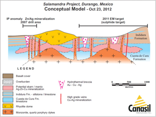
The exploration program to date at the Salamandra project indicate the potential for a large buried intrusive and carbonate hosted massive sulphide skarn/manto replacement system carrying silver, zinc, copper nd lead mineralization. The mineralized system is centered on a main rhyolite dome structure associated with an intrusive center in the project area. Widespread silver-copper-antimony-arsenic surface anomalies with peripheral lead and zinc anomalies are found over a very large area. Together with significant silver-zinc intercepts reported from drilling to the southwest of the rhyolite dome, and a very high grade silver-copper-zinc vein outcrop to the east of the dome structure, these geochemical anomalies are interpreted to be related to a buried intrusive and carbonate hosted massive sulphide skarn/manto replacement system under thin alluvial cover below and surrounding the rhyolite flow dome.
Initial sampling of mineralization observed on the southwest contact of the rhyolite dome returned significant silver and zinc values up to 7.84% zinc and 25 g/t silver over 3.2 meters. Follow up ground geophysics outlined chargeability anomalies below and to the southwest of the dome structure. Diamond drilling in this area returned significant silver and zinc-silver mineralization including 9.85 meters of 102 g/t silver and 0.55% zinc, 7.45 metres of 50 g/t silver and 12% zinc and 10 metres of 71 g/t silver, 3.48% zinc and 1.26% lead, as well as wider zones of lower grade zinc-silver mineralization. A follow up ZTEM airborne geophysical survey completed in 2011 outlined a much larger complex response area covering 2.5 km by 3.5 km, where detailed surface sampling led to the discovery of a high grade vein outcrop, carrying 2,150 g/t silver, 5.39% copper, and 1.89% zinc over 0.90 metres. Together with the extensive areas of anomalous silver-copper-arsenic-antimony with peripheral lead and zinc anomalies, these results indicate the potential for a large silver-zinc-lead-copper mineralized system. This mineralization is associated with skarn, hydrothermal breccias, sulphide rich veins and quartz porphyry dykes. Preliminary metallurgical testing on samples of mineralized drill core indicates high zinc and silver recoveries to clean concentrates.
Initial Evaluation Samples 2006:
The Salamandra project area had been historically investigated by the Mexican Geological Survey and by BHP for potential silver and base metal mineralization. There are signs of one or two historical drill holes by BHP on the flank of the rhyolite dome without any records or details and results from these drill holes. There has been no systematic historical exploration and drilling in the project area.
Initial Canasil chip and grab samples from mineralization observed along the contact of the rhyolite dome and surrounding basalt cover plain at the Salamandra project returned encouraging zinc and silver mineralization, grading up to 7.84% zinc and 25g/t silver over 3.2 metres. The mineralization is associated with fault and fracture replacement zones within a thin band of argilically altered and silicified siltstones and inter-bedded limestone along the south-western contact of the rhyolite porphyry intrusive. The principal mineralized target area at the project was considered to be in the flat areas covered by shallow gravel and basalt to the southwest of the mineralized sediment outcrops.
Nine samples taken from the contact area on the flank of the main intrusive body reported strong zinc and silver values as presented in the table below. Two check samples taken during a property evaluation visit in January 2006 confirmed the positive zinc and silver values reported, with anomalous copper grades.
Salamandra project, Durango, Mexico – historical and evaluation samples:
|
Sample Ref. |
UTM Coordinates
East North |
Elev.
(m) |
Width
(m) |
Gold
g/t |
Silver
g/t |
Lead
% |
Zinc
% |
Copper
% |
|
|
Historical Samples
|
|||||||||
|
426
|
567516
|
2670933
|
1937
|
Dump
|
0.05
|
12
|
0.07
|
3.76
|
0.08
|
|
427
|
567522
|
2670935
|
1934
|
Dump
|
0.16
|
10
|
0.05
|
3.44
|
0.04
|
|
428
|
567523
|
2670945
|
1934
|
3.20
|
0.09
|
25
|
0.07
|
7.84
|
0.34
|
|
429
|
567488
|
2670967
|
1944
|
25.00
|
0.02
|
4
|
0.06
|
1.62
|
0.01
|
|
430
|
567586
|
2670897
|
1931
|
12.00
|
0.08
|
16
|
0.23
|
3.03
|
0.03
|
|
431
|
567607
|
2670878
|
1944
|
Dump
|
0.04
|
16
|
0.22
|
1.40
|
0.04
|
|
432
|
567653
|
2670838
|
1943
|
10.00
|
0.03
|
20
|
0.35
|
1.35
|
0.04
|
|
433
|
567714
|
2670808
|
1946
|
15.00
|
0.02
|
10
|
0.17
|
0.47
|
0.01
|
|
434
|
567725
|
2670805
|
1940
|
Dump
|
0.04
|
10
|
0.17
|
0.41
|
0.02
|
|
Check Samples Jan. 2006
|
|||||||||
|
1762
|
567520
|
2670938
|
1934
|
3.00
|
0.19
|
39.8
|
0.10
|
6.59
|
0.52
|
|
1763
|
567517
|
2670929
|
1934
|
Dump
|
0.01
|
11.6
|
0.07
|
5.58
|
0.11
|
Exploration Program 2006-2007:
Canasil completed a 3-Dimensional Induced Plarization geophysical survey at the Salamandra project in October 2006 over an area of 2 km x 1.2 km covering the southwest flank and over the rhyolite dome. At the same time a geological mapping and surface sampling program was completed for additional surface information. Based on the results of these surveys drill targets were identified, and a diamond drill program of 12 drill holes for a total of 3,595 metres was completed in 2007. The drill program on the western flank of the interpreted intrusive source intersected wide zones of calc-silicate skarn with disseminated silver-zinc mineralization, averaging 0.5% - 1.0% zinc and 5 g/t - 20 g/t silver, and high-grade silver-zinc sulphide filled and structurally controlled breccia zones grading up to 20% zinc and 300 g/t silver. Initial metallurgical tests have also been completed on blends of high and low grade samples, returning high recoveries to clean concentrates, as well as petrographics and ore mineralogy on drill core samples.
Salamandra Zinc-Silver project, Durango State, Mexico
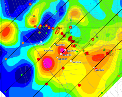
Phase 1 Diamond Drill Program, Drill Collar Locations on
Surface Zinc Geochemistry and Chargeability Profile at 150 metres depth.
|
Salamandra Project – Phase 1 Diamond Drill Holes SA-07-01 to SA-07-08
|
||||||
|
Zone/Interval
|
Sample Interval – metres
|
Width Metres
|
Grades
|
|||
|
From
|
To
|
Silver g/t
|
Zinc %
|
Lead %
|
||
|
SA-07-02
|
||||||
|
Zone 1
|
7.40
|
17.25
|
9.85
|
102
|
0.55
|
0.03
|
|
Zone 2
|
27.65
|
35.10
|
7.45
|
50
|
12.00
|
0.06
|
|
Zone 3
|
69.00
|
85.00
|
16.00
|
6
|
0.52
|
0.00
|
|
Zone 4
|
111.00
|
133.00
|
22.00
|
2
|
1.08
|
0.01
|
|
Zone 5
|
145.00
|
180.10
|
35.10
|
11
|
0.54
|
0.06
|
|
SA-07-03
|
||||||
|
Zone 1
|
116.40
|
127.00
|
10.60
|
16
|
1.60
|
0.26
|
|
Zone 2
|
195.00
|
215.00
|
20.00
|
45
|
2.62
|
0.77
|
|
Including
|
195.00
|
205.00
|
10.00
|
71
|
3.48
|
1.26
|
|
Zone 3
|
220.75
|
226.00
|
5.25
|
9
|
1.70
|
0.11
|
|
Zone 4
|
226.00
|
263.00
|
37.00
|
6
|
0.69
|
0.06
|
|
SA-07-04
|
||||||
|
Zone 1
|
48.00
|
88.80
|
40.80
|
15
|
0.32
|
0.21
|
|
Zone 2
|
194.77
|
224.08
|
29.31
|
13
|
0.74
|
0.16
|
|
Including
|
196.00
|
204.00
|
8.00
|
26
|
1.39
|
0.35
|
|
And
|
214.00
|
222.00
|
8.00
|
9
|
1.04
|
0.11
|
|
SA-07-05
|
||||||
|
Zone 1
|
212.00
|
256.00
|
44.00
|
2
|
0.32
|
0.02
|
|
Zone 1
|
256.00
|
268.56
|
12.56
|
13
|
1.78
|
0.02
|
|
Including
|
262.00
|
267.66
|
5.66
|
19
|
2.75
|
0.03
|
|
SA-07-06
|
||||||
|
Zone 1
|
3.40
|
15.00
|
11.60
|
13
|
4.05
|
0.03
|
|
Including
|
3.40
|
8.40
|
5.00
|
7
|
3.42
|
0.03
|
|
And
|
9.10
|
13.80
|
4.70
|
20
|
6.12
|
0.05
|
|
Zone 2
|
88.00
|
108.00
|
20.00
|
13
|
0.80
|
0.10
|
|
Including
|
100.00
|
106.00
|
6.00
|
2
|
1.34
|
0.04
|
|
Zone 3
|
180.60
|
225.10
|
44.50
|
3
|
0.80
|
0.04
|
|
Including
|
204.00
|
212.00
|
8.00
|
4
|
1.46
|
0.06
|
|
SA-07-07
|
||||||
|
Zone 1
|
98.00
|
126.00
|
28.00
|
11
|
0.93
|
0.10
|
|
Including
|
98.00
|
99.40
|
1.40
|
30
|
1.28
|
0.08
|
|
And
|
118.00
|
126.00
|
8.00
|
18
|
2.07
|
0.05
|
|
Zone 2
|
140.10
|
184.00
|
43.90
|
7
|
0.77
|
0.05
|
|
Including
|
140.10
|
152.00
|
11.90
|
9
|
1.36
|
0.05
|
|
And
|
174.00
|
178.00
|
4.00
|
12
|
1.63
|
0.12
|
|
SA-07-08
|
||||||
|
Zone 1
|
195.60
|
201.50
|
5.90
|
11
|
0.61
|
0.41
|
|
Zone 2
|
209.00
|
231.00
|
22.00
|
6
|
0.28
|
0.10
|
|
Zone 3
|
261.00
|
271.00
|
10.00
|
29
|
3.51
|
0.42
|
|
Including
|
261.90
|
265.43
|
3.53
|
72
|
4.75
|
1.03
|
|
And
|
267.40
|
269.50
|
2.10
|
4
|
7.91
|
0.04
|
|
Zone 4
|
321.75
|
335.00
|
13.25
|
4
|
0.57
|
0.00
|
Drilling in this area of the Salamandra project indicates that zinc-silver minerlization is associated with fracture controlled and disseminated replacement zones in hornfelsed limy sediments in contact with a quartz porphyry intrusive. Zinc-silver mineralization consists of higher grade sections from 5 -10 meters in width grading between 2% -12% zinc and 10 g/t - 100 g/t silver, within wider mineralized sections of 20 - 45 metres in width grading from 0.32% -1.08% zinc and 2 g/t – 45 g/t silver In drill holes SA-07-02 to SA-07-08, the weighted average of all 489.07 metres of lower grade mineralized drill intersections is 1.09% zinc and 12.65 g/t silver, and the weighted average grade of 55.26 metres of higher grade intercepts is 4.73% zinc and 54.73 g/t silver. This initial program indicates the discovery of a potentially large zinc-silver mineralized system, including sections of high grade mineralization, at the Salamandra Project. Soil and rock geochemical sampling indicate the mineralized trend extends on strike for an additional 1,000 meters.
A further 4 drill holes (SA-07-09 to SA-07-12) continued to intersect significant higher-grade zinc and silver intercepts within broader zones of lower grade mineralization. They extended the area over which the zinc-silver mineralized system is observed at the Salamandra project from 500 metres to 700 metres along strike. Eleven of the twelve drill holes have intersected zinc-silver mineralized zones with significant grades and widths. These mineralized zones appear to be part of a potentially large mineralized system, which is open along strike and to depth, and only a small part of which has been explored to date.
|
Salamandra Project – Phase 1 Diamond Drill Holes SA-07-09 to SA-07-12
|
||||||
|
Zone/Interval
|
Sample Interval - metres
|
Width Metres
|
Grades
|
|||
|
From
|
To
|
Silver g/t
|
Zinc %
|
Lead %
|
||
|
SA-07-09
|
||||||
|
Zone 1
|
48.00
|
56.00
|
8.00
|
22
|
0.48
|
0.08
|
|
Zone 2
|
249.00
|
275.00
|
26.00
|
13
|
0.81
|
0.18
|
|
Zone 3
|
281.65
|
284.15
|
2.50
|
4
|
3.22
|
0.01
|
|
Zone 4
|
326.00
|
329.00
|
3.00
|
12
|
1.86
|
0.04
|
|
Zone 5
|
355.10
|
363.30
|
8.20
|
4
|
2.09
|
0.01
|
|
Includes
|
355.10
|
357.50
|
2.40
|
4
|
3.00
|
0.01
|
|
And
|
360.50
|
363.30
|
2.80
|
6
|
2.59
|
0.01
|
|
|
|
|
|
|
|
|
|
SA-07-10
|
||||||
|
Zone 1
|
61.00
|
70.00
|
9.00
|
1
|
0.76
|
0.01
|
|
Zone 2
|
182.18
|
240.00
|
57.82
|
4
|
0.78
|
0.06
|
|
Zone 3
|
200.00
|
204.70
|
4.70
|
18
|
1.47
|
0.30
|
|
Zome 4
|
222.70
|
238.00
|
15.30
|
3
|
1.93
|
0.02
|
|
Includes
|
230.00
|
234.35
|
4.35
|
5
|
5.51
|
0.05
|
|
|
|
|
|
|
|
|
|
SA-07-11
|
||||||
|
Zone 1
|
58.40
|
93.30
|
34.90
|
8
|
0.50
|
0.17
|
|
Includes
|
58.40
|
62.20
|
3.80
|
40
|
1.30
|
1.16
|
|
|
|
|
|
|
|
|
|
SA-07-12
|
||||||
|
Zone 1
|
120.00
|
125.00
|
5.00
|
4
|
1.52
|
0.05
|
|
Zone 2
|
199.15
|
260.00
|
60.85
|
6
|
0.51
|
0.06
|
|
Inlcudes
|
199.15
|
204.00
|
4.85
|
9
|
0.91
|
0.11
|
|
and
|
215.00
|
217.50
|
2.50
|
19
|
1.23
|
0.14
|
|
and
|
226.00
|
237.00
|
11.00
|
7
|
1.06
|
0.07
|
|
and
|
228.50
|
230.90
|
2.40
|
10
|
2.87
|
0.09
|
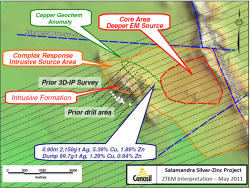
ZTEM Airborne Survey and Surface sampling 2011-2012:
In 2011 a ZTEM airborne geophysical survey was completed over the entire Salamandra claim block, covering 120 square kilometres (12,000 hectares) with 617 line-km of survey flights (62 lines,10 km per line with a 200 metre line spacing) providing electromagnetic and magnetic geophysical data. This survey outlined a large complex response area of 2.5 km by 3.0 km located to the east of the rhyolite dome structure, indicating a much lrger mineralized system. This area of low resisitivity and flat magnetic response was interpreted as an intrusive source, bounded by a north trending large regional fault on the east, and crosscut by several east–west fault zones. According to Frank Fritz, Canasil’s consulting geophysicist: “these are favourable locations for structurally controlled mineralization”.
Detailed surface sampling over this area discovered a high-grade vein outcropcarrying 2,150 g/t silver, 5.39% copper, 1.89% zinc over 0.90 metres, and extensive areas of silver-copper-zinc-lead-arsenic-antimony anomalies, which further confirm the potential for a large silver-zinc-copper mineralized system.
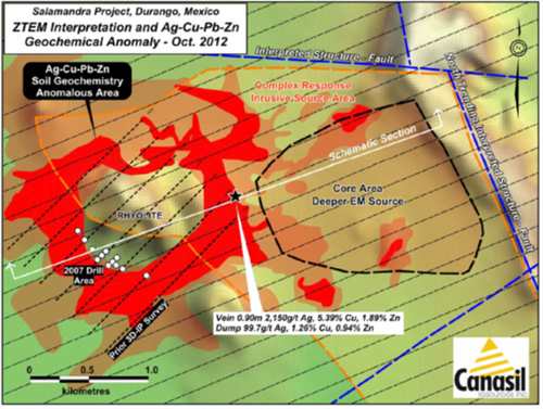
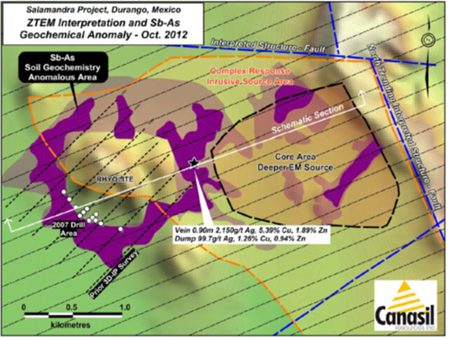
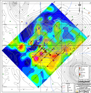
Salamandra Project ZTEM Response Area and High-grade Silver, Copper, Zinc Samples:
Surface Sampling of ZTEM Response Area 2012:
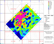
Further surface sampling and mapping was completed in 2012, providing for a comprehensive surface sampling and mapping program covering the ZTEM response area of 3.5 km by 4.5 km. This included the collection of 949 samples (829 soil samples, 76 rock samples and 44 chip samples) covering the ZTEM airborne anomaly, as well as areas surrounding the main rhyolite dome structure associated with an intrusive center in the project area. The sample results show widespread silver-copper-antimony-arsenic anomalies with peripheral lead and zinc anomalies over a very large area. Together with significant silver-zinc intercepts reported from earlier drilling to the southwest of the rhyolite dome, and the high grade silver-copper-zinc vein outcrop to the southeast of the dome structure, these geochemical anomalies are interpreted to be related to a buried intrusive and carbonate hosted massive sulphide skarn/manto replacement system under thin alluvial cover below and surrounding the rhyolite flow dome. The areas of silver-copper-lead-zinc anomalies and arsenic-antimony anomalies are shown in the maps below.
Salamandra Exploration Target:
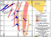
The interpreted intrusive source outlined by the ZTEM survey is alluvium covered and has not been drill tested. There is excellent potential in this area to outline disseminated mantle replacement or high-grade breccia associated silver, zinc and copper mineralization related to acid quartz porphyry intrusives, similar to the large San Martin mine of Grupo Mexico, located 80 km to the southeast. A conceptual section model of the potential mineralized system is included for reference.
MAG Silver Corp. exploration program, 2013 – 2015:
MAG reported $5.8 million in expenditures at Salamandra covering exploration programs including surface sampling and data review in 2013, followed by diamond drill programs for a total of 14,382 metres in 23 drill holes between 2013 and 2015. The surface sampling and data review identified major indicators of large carbonate replacement deposits at Salamandra.
Common features of large known CRD deposits observed at Salamandra:
1. Location – main street CRD belt
2. Ag (+400 g/t), Au, Zn, Pb, Cu, + Mn, As, W ....
3. Multiple mineralization and alteration stages
4. Large scale zoning
5. Located on top of carbonate section (room to grow)
6. Presence of Felsite dykes
7. Presence of Skarn
8. Discordant geometry (not syngenetic)
9. Replacement mineralization
10. High Iron Sphalerite
11. Pyrite pseudo-morphs and pyrrhotite
12. Molybdenum mineralization
13. Granitic Stock Contact Skarn = Target
Salamandra 2013 – 2015 drill programs:
The drill programs reported encouraging high-grade silver-copper-zinc intercepts, pervasive zinc mineralization, and an interesting interval of gold-tungsten mineralization. Highlights of the MAG drill programs at Salamandra included the following drill holes:
- SA14-15 intersected high-grade silver-copper mineralization over 7.89 metres, assaying 166 g/t Ag and 1.2% Cu, including 2.3 metres grading 393 g/t Ag and 3.6% Cu with anomalous lead and zinc;
- SA13-13 cut 31.72 metres grading 3.5% Zn including 17.72 metres grading 5.0% Zn with no other anomalous metals. Notably, SA13-13 contained zinc mineralization for almost its entire length, with 810 metres averaging 0.6% Zn including several thick zones grading over 1.5% Zn;
- SA14-14 returned two intercepts, one with 0.48 metres of 197 g/t Ag, 0.4% Cu and 1.1% Zn, and the second with 0.42 metres of 108 g/t Ag, 0.5% Cu, and 0.6% Zn;
- SA14-20 cut 0.63 metres grading 258 g/t Ag with 0.27% Cu lying immediately above 9.9 metres grading 2.3% Zn;
- SA14-19, 22, and 24 all cut significant widths of zinc mineralization; hole SA14-28 cut 173.46 metres of 1.0% Zn starting 20 metres below the surface;
MAG concluded that Salamandra manifests signs of an extensive, complex system with a strong metals endowment. Pervasive zinc mineralization intersected in most of the drill holes, the high-grade silver-copper intercepts and deeper gold and tungsten intercepts indicate the potential for a large metalliferous system at Salamandra. This system remains open for expansion through additional drilling.
Qualified Person, Quality Assurance and Control: The above results were compiled and provided by MAG; for details regarding the Qualified Person and Quality Assurance and Control procedures, please refer to the MAG news release dated March 17, 2014 for the Phase-1 results, and July 21, 2014, for the Phase-2 results, and December 17, 2015, for the Phase-3 results.
Salamandra 2013 – 2015 Drill Program Map and Significant Drill Intercepts:
| Salamandra Project, Durango, Mexico – Selected 2013 – 2015 Drill Intercepts | ||||||
| Drill Hole | Intercept From – To: m |
Width m |
Silver g/t |
Zinc % |
Copper % |
Lead % |
| SA-13-13 | 20.65 – 830.81 | 810.16 | 2 | 0.6 | 0 | 0 |
| Incl. | 637.50 – 669.22 | 31.72 | 1 | 3.6 | 0.1 | 0 |
| SA-14-14 | 165.99 – 182.88 | 16.89 | 29 | 1.8 | 0 | 0.2 |
| Incl. | 182.40 – 182.88 | 0.48 | 197 | 1.1 | 0.4 | 0.6 |
| And | 186.38 – 186.80 | 0.42 | 108 | 0.6 | 0.5 | 1.4 |
| SA-14-15 | 605.74 – 613.13 | 7.89 | 166 | 1.2 | 1.2 | 0.6 |
| Incl. | 607.50 – 609.80 | 2.30 | 393 | 2.8 | 3.6 | 0.4 |
| SA-14-19 | 128.87 – 130.22 | 1.35 | 59 | 0.9 | 0 | 1.1 |
| And | 349.87 – 388.36 | 37.99 | 1 | 1.6 | 0.02 | 0 |
| SA-14-25 | 113.00 – 143.51 | 30.51 | 25 | 0.8 | 0.02 | 0.4 |
| Incl. | 121.36 – 126.73 | 5.37 | 41 | 1.7 | 0.02 | 0.7 |
| And | 138.58 – 143.51 | 4.93 | 77 | 1.9 | 0.03 | 1.3 |
| SA-14-27 | 358.40 – 366.00 | 7.60 | 2 | 2.2 | 0.03 | 0.2 |
| Incl. | 358.40 – 360.68 | 2.28 | 5 | 3.5 | 0.04 | 0.2 |
| And | 364.12 – 366.00 | 1.88 | 2 | 4.4 | 0.05 | 0.4 |
| SA-14-28 | 19.90 – 193.36 | 173.46 | 4 | 1.0 | 0.01 | 0.1 |
Maps
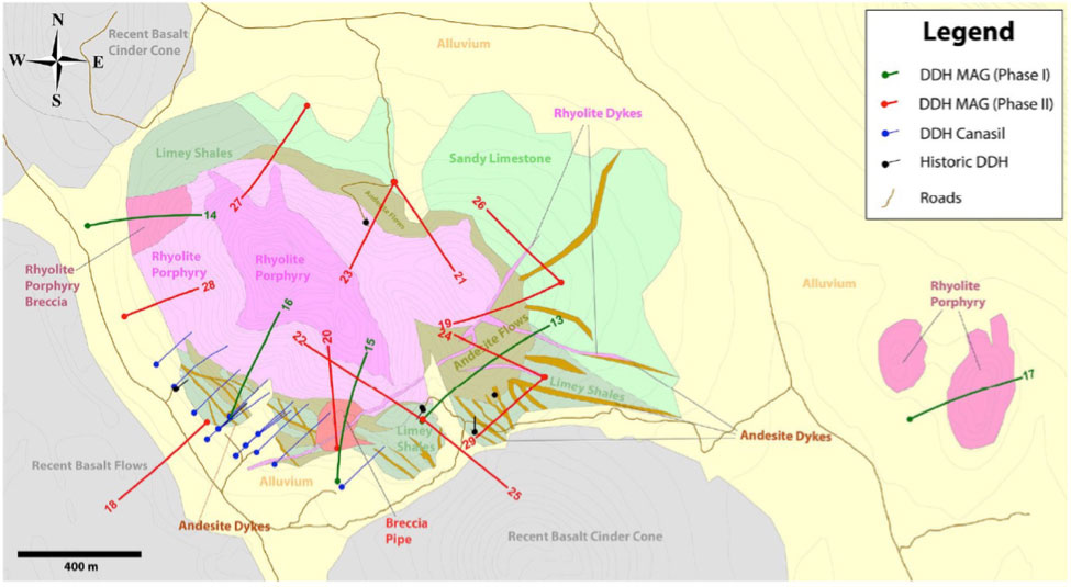
Salamandra Project Geology Map

Salamandra 3D-IP Geophysics Sections
Salamandra 3D-IP Chargeability Plan Maps
3D-IP Resistivity Plan Maps
Salamandra Geochemical Rock & Soil Samples Maps
Salamandra Phase 1 Drill Plan
Salamandra Drill Sections with Ag and Zn Intercepts
Salamandra Drill Area Surface and Projected Geology Plan
Salamandra Geophysics Chargeability Trends and Targets
Photos

Salamandra location and photos